Learn bits
Science & Tech.
Mahesh

02/11/24 13:06 PM IST
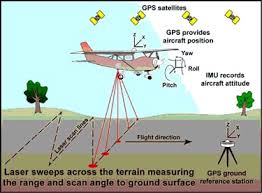
LiDAR system

In News
  • Scientists have detected a lost Mayan city, hidden for centuries by the dense Mexican jungle, using LiDAR.
About LiDAR
  • LiDAR, or Light Detection and Ranging, is a  remote sensing technology that uses light in the form of a pulsed laser to measure ranges (or variable distances) of a sensor, usually mounted aboard an aircraft, to Earth’s surface.
  • LiDAR data can be used to create high-resolution 3-D models of ground elevation with a vertical accuracy of upto 10 cm, according to the US Geological Survey.
Working of LiDAR
  • LiDAR instrumentation comprises a laser, a scanner, and a GPS receiver.
  • The rapidly firing laser travels to the ground where it hits vegetation, building, and various topographic features.
  • This light is reflected or scattered, and recorded by the LiDAR sensor.
  • The system calculates the light pulses’ two-way travel time to arrive at the distance between the terrain and the sensor.
  • It processes this information with Global Positioning System (GPS) and Inertial Measurement System (IMS) data, to create an elevation map of Earth.
  • LiDAR data is initially collected as a “point cloud” of all individual points reflected from everything on the surface, including structures and vegetation.
  • But the specifics of how much light energy was returned to the sensor allows further identification of different features, such as vegetation, buildings, etc.
  • For example, tree canopies, however dense they may be, allow some light to pass through and hit the ground.
  • The LiDAR data can be further refined to produce what scientists call a “bare earth” Digital Elevation Model, in which structures and vegetation are stripped away.
Benefits of LiDAR
  • LiDAR is used to generate precise, three-dimensional information about the shape of the Earth and its surface characteristics.
  • This is obviously very useful information for geographers, policy makers, conservationists, and engineers.
  • In recent years, however, LiDAR has also shown potential as a tool of archaeological discovery.
  • The city “has all the hallmarks of a Classic Maya political capital: multiple enclosed plazas connected by a broad causeway, temple pyramids, a ballcourt, a reservoir formed by damming an arroyo (a seasonal watercourse), and a probable … architectural arrangement that generally indicates a founding date prior to 150 CE.
Source- Indian Express

More Related Current Affairs View All

28 Aug

IADT-1

'Recently, the Indian Space Research Organisation (ISRO) successfully carried out its first Integrated Air Drop Test (IADT-1), a crucial milestone in the preparation for the countr

Read More

28 Aug

H-1B visa changes

'H-1B visa changes 2025: United States Commerce Secretary Howard Lutnick called the popular H-1B visa program a “scam”, saying that American businesses should be focuse

Read More

28 Aug

UGC’s Learning Outcomes-based Curriculum Framework

'Recently, the University Grants Commission (UGC) issued a public notice on its development of a draft Learning Outcomes-based Curriculum Framework (LOCF).' LOCF is intended to

Read More

India’s First Ai-Driven Magazine Generator

Generate Your Custom Current Affairs Magazine using our AI in just 3 steps